The prehistory of the Land of Nineveh
Introduction
Since the middle of the last century, when Ralph Solecki excavated the Neanderthals at Shanidar and Robert Braidwood began his work at Jarmo, the ‘hilly flanks of the Zagros’ have been a mythical place for the study of prehistory (Braidwood & Howe 1960; Solecki 1971). Despite its crucial importance for early human history and its high archaeological potential, this extensive region—encompassing parts of Iraq, Iran and Turkey—has, until the recent establishment of several research projects, not been subject to systematic exploration. In September 2015, a joint team from the universities of Udine, Rome (‘La Sapienza’) and Milan initiated a field project focused on the prehistory of the provinces of Nineveh (Mosul) and Dohuk, in the northernmost part of Iraqi Kurdistan. The purpose of this study is to outline the main chrono-cultural aspects of the region’s prehistory, from the Lower Palaeolithic to the early Chalcolithic, and to relate them to environmental changes that have occurred since the Middle Pleistocene. This research is part of the broader ‘Land of Nineveh Archaeological Project’, led by Udine University, that has been running since 2012 with the aim of understanding the formation and evolution of the cultural and natural landscape of this region from the Palaeolithic to the Islamic period (Morandi Bonacossi & Iamoni 2015).
The survey
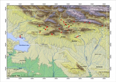
The study area covers 2900km2 and is delimited by the plain of Dohuk and the Zagros foothills to the north, the lake formed by the Eski Mosul Dam to the west, the piedmont plain that extends to the Jebel Maqlub and Bardarash regions to the south, and the River Al-Khazir to the east (Figure 1). The region being investigated here consists of different geographical units, including mountains, foothills, intermontane basins and valleys, and river terraces.
The first field season was devoted to a geoarchaeological survey of three sample areas: the intermontane valleys (Mkeris and Merseeda Valleys; the upper course of the River al-Khazir); the piedmont areas and river terraces (from the River Gomel to the Rubar Dashqalan); and finally, the plain and terraces above the former Tigris Valley along the left shore of the Eski Mosul Dam. A further goal of the survey was to locate sources of lithic raw materials.
The region’s geological bedrock mostly consists of limestone strata (Jassim & Goff 2006), which are prone to karstic processes, the most pertinent of which, for our purposes, is the occurrence of caves and rock shelters formed by rock dissolution. In the Land of Nineveh, caves and rock shelters are common, and in many cases they contain evidence of human occupation continuing until just a few decades ago.
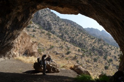
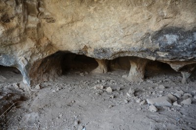
We can distinguish three main categories of rock shelter that may be of potential interest regarding the search for prehistoric sites. Caves correspond to the initial portions of long and complex karstic cavities (Figure 2), with high vaults and large, flat floors. The latter are generally covered by thick layers of dung, the result of long-term pastoral use. Sparse lithics occur on the floor surfaces and near cave entrances. Caves are also important for palaeoclimate studies, as speleothems preserve information on local variation in rainfall. We have also found lithic scatters in rock shelters and beneath collapsed roofs related to former caves or rock shelters. For example, site 744 features a thick breccia deposit containing Middle Palaeolithic artefacts, charcoal and faunal remains that were protected from erosion by the collapsed blocks of the rock shelter’s vault (Figure 3).
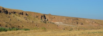
During the first survey campaign, 7 caves, 11 rock shelters and a collapsed roof sealing an anthropic deposit were found. Fifteen open-air sites were also identified, featuring lithic material from the Lower Palaeolithic to the Late Neolithic–Chalcolithic. These lithic scatters were found mainly on fluvial terraces and in correspondence with chert outcrops in the mountains (Figure 4).
Surveys along the Zagros foothills (Chiya-e-Zihera) overlooking the plain between the River Gomel and the village of Al Qosh revealed rich outcrops of chert and three chert mines of the ‘room-and-pillar’ type (Figure 4) with highly complex underground plans (site 782, Skafte Zeri Cave and sites 824 and 825), possibly dating from the Neolithic onwards (Figure 5).
Chronology and finds
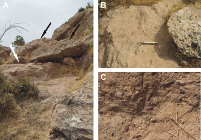
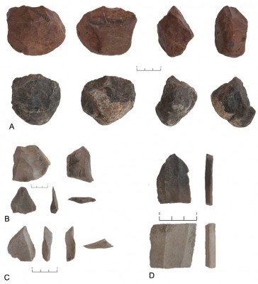
Two pebble cores collected on a fluvial terrace in a tributary wadi of the River Gomel (site 774) constitute the first Lower Palaeolithic evidence in the region (Figure 6A). Middle Palaeolithic (Levallois) cores, débitage and tools were identified in the valleys of Merseeda at site 744 and Atrush at site 758 (fluvial terrace), and, in the piedmont area, on fluvial terraces at sites 774, 727, 785 and 786. Late Palaeolithic materials (blade/bladelet cores and débitage products) were collected from fluvial terraces at sites 260, 747 and 755 (intermontane valleys), in the piedmont area at sites 765 and 727, and on the plain at site 775. A large number of lithic artefacts of Late Neolithic–Chalcolithic date were found at the open-air site of Gali Dakhas (776), on the north-east shore of the Eski Mosul Dam.
Conclusions
The sites identified in the area explored so far show the richness and variety of solutions adopted by human groups in prehistoric times, such as the early use of the mountains and intermontane valleys for seasonal subsistence activities and raw material exploitation, and the shift to more open areas, adjacent to the plains and near perennial water sources, during later phases. Furthermore, the identification of Lower Palaeolithic tools offers the opportunity to contribute to the discussion on hominin dispersal from Africa to Eurasia. A programme is planned for future field seasons, including surveys of zones not yet investigated, intensive surveys of limited areas and test trenches in caves and shelters in order to verify the extent of the deposits.
Acknowledgements
The Land of Nineveh Archaeological Project is extremely grateful to the General Directorate of Antiquities of the Kurdistan Regional Government (directed by Abubakir Othman Zeineddin), the Directorate of Antiquities of Dohuk (directed by Hassan Qasim Ahmad) and the State Board of Antiquities and Heritage in Baghdad for granting all necessary work permits and for their unflagging support and encouragement. Funding for the 2015 field campaign was provided by the Italian Ministry of Foreign Affairs and International Cooperation, the Friuli Venezia Giulia Regional Authority, the universities of Udine and Rome (‘La Sapienza’), the Udine and Pordenone Banking Foundation and a private sponsor (Giorgiutti & Associates Ltd).
References
- BRAIDWOOD R.J. & B. HOWE. 1960. Prehistoric investigations in Iraqi Kurdistan. Chicago (IL): University of Chicago Press.
- JASSIM, S.J. & J.C. GOFF. 2006. Geology of Iraq: Praha: Dolin.
- MORANDI BONACOSSI, D. & M. IAMONI. 2015. Landscape and settlement in the eastern upper Iraqi Tigris and Navkur Plains (northern Kurdistan region, Iraq). The Land of Nineveh Archaeological Project, seasons 2012–2013. Iraq 77: 9–40.
- SOLECKI, R. 1971. Shanidar: the first flower people. New York: Alfred A. Knopf.
Authors
* Author for correspondence.
- Cecilia Conati Barbaro*
Sapienza Università di Roma, Dipartimento di Scienze dell’Antichità, Piazzale Aldo Moro 5, 00185 Rome, Italy (Email: cecilia.conati@uniroma1.it) - Andrea Zerboni
Università degli Studi di Milano, Dipartimento di Scienze della Terra ‘Ardito Desio’, Via Luigi Mangiagalli 34, 20133 Milan, Italy - Daniele Moscone
Sapienza Università di Roma, Dipartimento di Scienze dell’Antichità, Piazzale Aldo Moro 5, 00185 Rome, Italy - Mauro Cremaschi
Università degli Studi di Milano, Dipartimento di Scienze della Terra ‘Ardito Desio’, Via Luigi Mangiagalli 34, 20133 Milan, Italy - Marco Iamoni
Università degli Studi di Udine, Dipartimento di Storia e Tutela dei Beni Culturali, Vicolo Florio 2/B, 33100 Udine, Italy - Alberto Savioli
Università degli Studi di Udine, Dipartimento di Storia e Tutela dei Beni Culturali, Vicolo Florio 2/B, 33100 Udine, Italy - Daniele Morandi Bonacossi
Università degli Studi di Udine, Dipartimento di Storia e Tutela dei Beni Culturali, Vicolo Florio 2/B, 33100 Udine, Italy

 Cite this article